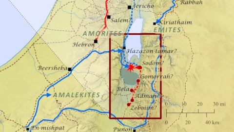
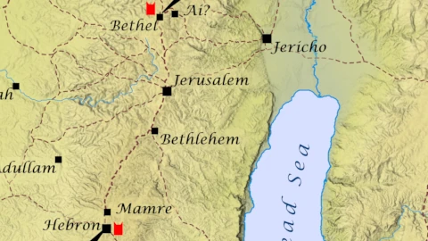
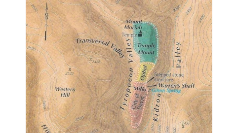
Jerusalem is built upon a cluster of seven hills in the Judean mountains about 30 miles east of the Mediterranean and 20 miles west of the northern shore of the Dead Sea. The elevation of the city varies from just over 2000 feet at the bottom of the Kidron Valley to over 2700 feet at the peaks of the Mount of Olives and Mount Scopus (not shown on this map). The topography of the area has been greatly changed by people through history. Originally, Mt. Moriah and Mt. Zion (labeled City of David on this map) were separated by a shallow depression which was later filled in by large earthworks – the Millo and the Ophel. Then a man-made platform built with large stone vaults was constructed on Mt. Moriah forming the “Temple Mount” we know today – the largest man-made platform in the world (150,000 square meters, 37 acres).
Study Type: Reference
Handouts, maps, genealogies, timelines, etc.
This map shows possible locations for the cities of the Dead Sea valley destroyed by God for their wickedness (Genesis 18). The precise location of these cities remains subject to scholarly debate. The map also shows the possible route Lot followed from Luz (Bethel) to Sodom when he and Abram parted ways after returning to Canaan from Egypt (Genesis 13), Lot’s possible escape route from Sodom to Zoar, and the route from Abraham’s tent at the oaks of Mamre to one possible location for Sodom.
This map shows the boundaries of the modern state of Israel. The areas highlighted in green are the so-called “occupied territories” taken by Israel during the 1967 Six-day War – Gaza, The West Bank (Judea and Samaria), and The Golan Heights (Bashan). These areas are now governed by the Palestinian Authority except Gaza which is … Read more
